Русский    Español       Home  Map   E-mail  
Digital Camera (Airborne Scanner) «3-DAS-1»
Digital Photogrammetric Station «Delta»
Color Photogrammetric Scanner «DeltaScan»
DPS «Delta» Software
Mapping and cartography
software «Digitals»
Download
software...
        About us     News     Dealers     Forum : Software

DPS «Delta» Software

Supports full photogrammetric production started from triangulation/adjustment to final symbolized map/ortho output.
Based on the «Digitals» mapping engine with stereo-plotting possibilities.
Allows to create nice-looking digital maps and orthophotos from areal or satellite images. Works in stereo mode with stereoscope or OpenGL shutters, works in mono/mono+ mode without an additional hardware.
Optionally uses handwheels/footdisk equipment: full DPS «Delta» workstation.

Orientation software

Processing aerial, close range and satellite images from various sensors.

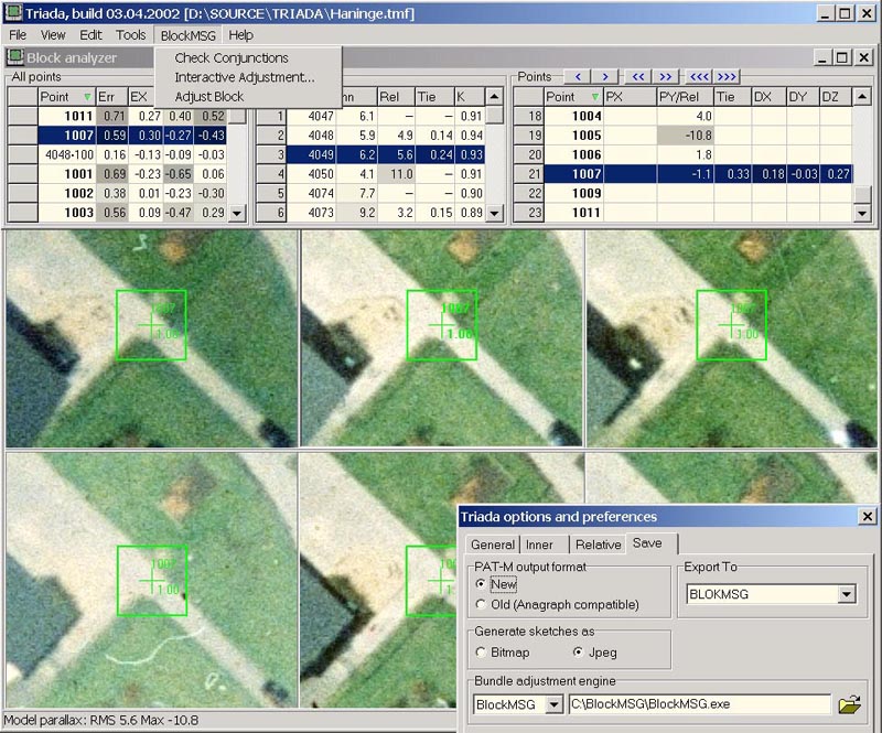
Managing cameras and ground/control points.

Importing absolute orientation elements from different formats.

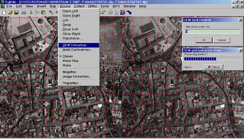
Semiautomatic orientation of stereo models and single photos.

Total error control and correction at every orientation stage.

Mapping software

Operates both with stereo models and with single photos (using DEM).

Three-dimensional superimposition of vector data on raster images.

Can be used for vectorization of orthophotos and scanned maps.

Allows to customize layers, symbols, object parameters and other map attributes.

Uses templates of standard object types to simplify data collecting.

The panel of favorite most used layers.

Automatic 2D/3D snap at points and lines with indication.

Automatic and semiautomatic DEM extraction, building and interpolation of contourlines.

Raster maps and photos in TIFF (including JPEG and ZIP compressed), RAW, JPEG and BMP formats can be used.

Operates with huge black-and-white and color raster images on a standard computer.

Supports popular vector formats: DWG, DXF/DBF, Shape, DGN, MID/MIF, ASCII, etc.

Real-time coordinates exchange with other programs via TCP/IP, OLE and COM-port.

Orthophoto mosaicking

Creation of a mosaic of any number raster polygons from different photos.

Orthophoto software

Creation and editing of raster/vector orthophoto maps with frame, grid and
legend using any fonts and symbols.

Orthophotomap

Terrain-related functions

Automatic DEM extraction for orthophoto and building contourlines.

Creation of a regular DEM-grids and TINs based on spot-heights and/or contourlines.
Building contourlines using a DEM or a TIN.

Contourline interpolation.

Assign of height to every map object according to spot-heights and contourlines.

Creation of profiles and sections, volume calculations.

DEM-grid editing using shutter glasses or stereoscope.

Import of DEM data from ASCII text or DXF format as spot-heights and/or contours.

Automatic triangulation

Contains own bundle adjustment engine BlockMSG for on-line adjustment and control.

Uses ground points and GPS data with automatic boresighting calculation.

Quick correlation algorithm for automatic point transfer.

Full quality control using correlation, parallaxes and tie-point errors.

Automatic and semiautomatic modes of measurement.

Filtering measured points using various criteria.

Convenient tools for block analysis and error detection, sorting models and points by any parameters.

Uses 3D-mode for accurate ground points measurements.


Mapping software «Digitals»

Provides unlimited possibilities for creating/editing/revising of digital maps.

  See DPS Delta specification for more information.

  Download DPS «Delta»software and manuals

© 2004-2019 «Analytica» Ltd  
Home    Map    E-mail            About us        News        Dealers