Mapping and cartography software «Digitals» |
|
The mapping software is designed for creation/revision of topographic and special maps, map publishing, urban cadastre and land management, solving special tasks.
Provides unlimited possibilities for creating/editing/revising of digital maps.
Supports 3D-input from DPS «Delta» and external formats.
|
|
|
Basic cartographic engine supports
- Unlimited list of layers that define the appearance of objects: line and fill attributes, associated cartographic symbol and other properties;
- Unlimited number of object parameters (database fields) and a possibility of arbitrary placement of their values on the map as captions
- Editable library of vector cartographic symbols that contains ordinal, linear, linear-oriented, linear-scalable and areal symbols;
- Changeable order in which layers or single objects are displayed;
- WYSIWYG mode: the map is displayed on the screen just as it will be output on a printer, plotter, to BMP file;
- Saving maps along with its attributes in a single file.
|
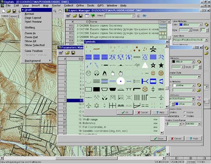
Draft view (basic digital model) and visual settings for objects
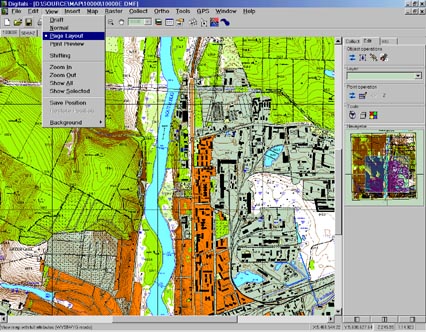
Page layout mode utilizes all the attributes of objects
|
|
|
|
|
Software features
Multidocument interface with support for standard Copy, Cut and Paste operations within a window or between multiple windows;
Group selection/search of objects by any combination of parameters, performing any operations on the all selected objects simultaneously;
Possibility to enrich with cartographic symbols, color attributes, etc. digital maps created in other systems;
Support for DWG, DXF+DBF, Shape, DGN, MID/MIF, ASCII, etc. formats;
Creating arbitrary types of frames and legends and automatic insertion them into maps;
Creating map templates.
|
|
|
|
|
Mapping by using raster images or stereoplotter
Supports data collection over scanned maps and single photos in TIFF and BMP formats;
Works with black-and-white and color images up to 4 Gb large on standard computers;
Collection using templates of standard object types, automatic polygon assembling;
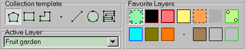
Panel for quick selection of favorite layers
Automatic snap to lines/points of existing objects in collection mode;
|
|
|
|
|
Relief-related functions
Creating a regular DEM-grid based on spot-heights and/or contourlines;
Building contourlines using a previously created DEM;
Contourline Interpolation;
Reassigning height to all map objects based on spot-heights and/or contourlines;
|
|
|
|
|
Cadastre and land management
Creation of cadastral maps and schemes;
Filling database fields for every object with a search function;
Creation of reports, land distribution lists, custom graphic and text documents;
Automatic area calculation, adjustment of measuring units and formatted output;
Interaction with office applications.
|
|
|
|
|
 Download «Digitals» software and manuals
|